In 2007, I explored the cliff dwellings and ruins of the Anasazi Native American tribe. My father, friends and I hiked, loaded on our back with gear and food for three days, to the sandy bottom of the canyon.  A sign warned of quicksand where wild horses galloped around spots of shimmering mud similar to other creek puddles. I made sure to stay clear, following the horses that seemed to have an innate knowledge of the quicksand’s power for swallowing life.

For two days, we explored the ancient cliff dwellings in Northern Arizona. A guide stationed in a nearby cabin led us up wooden ladders hugging the canyon wall to past homes of the Anasazi people.
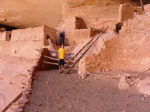
keet-seel-ruins

The Keet Seel ruins look over the Tseigi Canyon. They seem to be almost perfectly placed in the canyon wall, using nature as protection against bad weather and enemies. The ruins remain one of the most preserved ruins of the Anasazi tribe. Pottery scattered each room of the ruins and wooden posts stood outside, where birds were tied to, according to the guide.

There are 160 rooms in Keet Seel, as well as six ceremonial houses, called Kivas.

Hikers and backpackers should know that permits are required for this location, and should be requested at least three weeks in advance. Permits can be purchased by calling 928-672-2700.
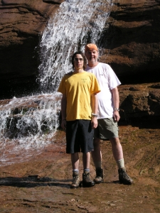
Keet Seel waterfall

The trail leading to the ruins is approximately 17 miles round trip. At times, this can be a fairly rough hike because of the amount of sand in certain areas. You will also have to cross the creek at times, sometimes passing by small waterfalls.

The trail is located on Navajo National Monument, located at  US Highway 160 and State Highway 564. From Flagstaff, take the 89 to US 160, along which you will see signs for the Navao National Monument. Follow the signs to the visitor center and obtain directions to the trailhead for Keet Seel.

You will want to start your hike early to allow for enough time to make it into the canyon. Campsites are located near the trailhead, where you can camp the night before setting out on your adventure.
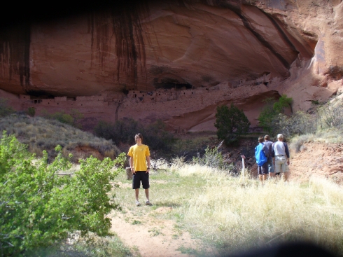
Keet Seel ruins

One of my main purposes of creating this blog was to incorporate moderately accessible camping areas in Arizona. I found that many Arizona residents are unaware of some of the valleys and canyons that exist in this surreal southwestern state, and would love to share some of my fun adventures.

One of my favorite camping locations in Arizona is called Bull Pen Ranch, located in Yavapai County. This area is in the middle of Cococino National Forest, near the city of Camp Verde. There are many hiking trails around the area, in addition to campgrounds. I found there are generally many people who enjoy riding ATVs along dirt roads that wind through nearby mountains.

West Clear Creek cuts its way through the  Bull Pen Ranch campground. The water varies in height, depending on rainy/snowy weather. I have seen the creek rise incredibly fast during storms, so I advise hikers and campers to be check weather predictions before heading out on their trip.

The summer is a great time to camp here, because the creek provides nice swimming areas. The hiking is also beautiful, and you can actually find some Native American ruins on the cliffs. They look like small circles of rocks that made up individual rooms used by the tribes.

I usually take my Honda Accord camping at Bull Pen Ranch, however the dirt roads entering the campground are extremely narrow and covered with boulders/rocks. My car has had its fair share of dents from boulders in this area. Usually a truck or SUV is advised, but I managed to slowly get  my Accord through the rough spots.

Directions from Phoenix: Take the I-17 North to Camp Verde (exit 285), turn East onto Highway 260 and proceed approximately seven miles. Between mile posts 226 and 227 and turn left onto FR618. This part is a little tricky because the FR618 sign is not too big.  There is a metal cutout of a cowboy on the right side of the road. I generally use that as a marker, as FR618 is the first right directly after the cowboy. FR618 is a dirt road you will follow until the first main turnoff to the right (about a two miles down), which is called FR215. I do not believe there is a sign for this turnoff. Follow this two miles into the campsite (you will see signs stating “Bull Pen Ranch”).

Be safe, bring plenty of water and have a blast!

The Superstition Mountains are relatively close to the Phoenix area with a wide range of trails varying in lengths from backpacking trips to day hikes. The Superstitions are a wonderful place to hike all year round; however, I prefer the Spring and Summer times, due to the wildflowers that abundantly bloom. Arizona’s monsoons provide a perfect environment for wildflowers, filling the land with vibrant fields of yellow and red along the Superstition trails. For those who enjoy photographing nature , the flora allows for postcard-material photographs.

The Peralta trail is, without a doubt, one of the most popular trails, yet also one of my favorites. The path follows a dry creek bed of the Peralta Canyon through the first mile or so of the hike, before turning into switchbacks that take you to the top of the mountain range. At the end, there is a gorgeous view of the valley below with Weaver’s needle reaching out from the heart. Weaver’s needle, a column of rock, extends approximately 1,000 feet above the valley to an elevation of about 4,500 feet.

After rainy weather, the beginning creek fills with water, providing a few luxurious wading areas in rock baths, perfect for cooling off during the summer’s blazing heat.

The total distance of the Peralta trail is about 6 miles. I find it is fairly easy to accomplish this hike in five or six hours, depending on your hiking pace.

The Lost Dutchman’s Gold Mine is also a major attraction of the Superstitions, as well as the origination of its name. The hidden treasure revolves around a theory of lost gold buried in the Superstitions, supposedly left by a mining prospector in the late 1800s.

Directions to Peralta trailhead: From Phoenix, go east on U.S. route 60 past Apache Junction. Turn left (North) on Peralta Road (FS77) and travel about 8 miles to the parking area.  You will pass a neighborhood on the way in, before the pavement turns into a dirt road leading up to the mountain.

I created this blog to explore and portray new products, trails, campgrounds, tips, food recipes and survival/safety issues incorporated in hiking and camping in the beautiful state of Arizona. I grew up in Tempe, AZ, where I began hiking and camping at a young age. My experience initially began through my membership with the Boy Scouts of America. Throughout the years, I have gained a huge appreciation for the outdoors, especially in Arizona. In my opinion, there are many people who are unaware of the wonderful beauty within the natural landscapes of Arizona. I have a strong desire to portray some of what I feel are the most eloquent expressions of nature that Arizona has to offer.

With this blog, I want to provide a consistent update of the current conditions at different hiking and camping locations. There are a large amount of sites to explore in Arizona – this blog will allow me to keep a personal track of favorite hikes and camping excursions.

While I do not have a large amount of time for hiking and camping in my life, I discovered many locations suitable for nice day trips and hikes.

I want to kick off my first post with one of my favorite hiking location that is very close to the city of Tempe. It allows for an short, easy hike for the morning or evening, as well as longer trails taking you through sand washes and views of the city from the top of the mountain.

I began exploring the trails of South Mountain in high school, and have been regularly hiking there every since. This is a very popular location, but there are many hidden washes and trails that will take you from the city into nature in less than an hour. For a short hike or run, I recommend the trail beginning at Pima Canyon. This area provides a large availability of parking and has easy access to the main trail. The Pima Canyon parking area is located on 48th Street and Guadalupe. There are a few trails to choose from, depending on how long of a hike you wish to pursue. The one that is fairly short is the main trail directly at the end of the parking lot. It is a very popular hike, and many runners use it to train. It serves as a nice hike that won’t take more than an hour or so.

A wash begins directly behind the bench at the end of this trail. It is one of the most beautiful areas if someone wanted to add a little more to their hike at South Mountain. Many outdoor enthusiasts who enjoy bouldering can frequently be seen bringing in crash pads to large rock formations that serve as perfect bouldering areas. White chalk can be seen on some large rocks, mapping out frequently used  routes.

Site Information

Welcome! My name is Mark Crudup, and I am a graduate from Arizona State University with a degree in journalism and mass communication. Being an avid outdoor hiker, Arizona-native and writer, I've dedicated this site to exploring Arizona hiking and camping locations. May you find beauty in this state's natural, desert oasis!